Papers by Irini Malliaros
Signals Signals - The Journal of the Australian National Maritime Museum, 2024
King Island, in Bass Strait, is infamous for the many shipwrecks in its waters. Among them is the... more King Island, in Bass Strait, is infamous for the many shipwrecks in its waters. Among them is the Cataraqui, an emigrant barque that wrecked on the island’s west coast in 1845 with the loss of more than 400 lives.
Earlier this year, Kieran Hosty, Irini Malliaros and Julia Sumerling visited the site of Australia’s worst civil maritime disaster.

Historical Archaeology, 2023
In early 2018, a collaborative team composed of maritime archaeologists, museum specialists, and ... more In early 2018, a collaborative team composed of maritime archaeologists, museum specialists, and volunteers from the South Australian Department for Environment and Water, South Australian Maritime Museum, Silentworld Foundation, Australian National Maritime Museum, MaP Fund, and Flinders University surveyed for and located the shipwreck site of the bark South Australian. Lost at Rosetta Harbor (at the western end of modern-day Encounter Bay) in December 1837, South Australian is South Australia’s oldest documented shipwreck. Its significance also derives from its use as one of the earliest immigration ships to ferry European settlers to the colony of South Australia, as well as careers as a postal packet and “cutting-in” vessel for shore-based whaling activities. South Australian’s historical background is addressed, as are efforts to locate and confirm the identity of its wreck site via archaeological investigation.
Signals - The Journal of the Australian National Maritime Museum , 2021
In September 2018, archaeologists from the Silentworld Foundation and the Australian National Mar... more In September 2018, archaeologists from the Silentworld Foundation and the Australian National Maritime Museum were invited by Casey & Lowe Pty. Ltd. and Cosmos Archaeology Pty. Ltd to participate in the excavation and recovery of an early 19th-century timber boat from the former shoreline of Cockle Bay at Barangaroo, Sydney. The Silentworld Foundation and the York Archaeology Trust, assisted by the Museum and Ubi3D are now leading the conservation effort, financed by Sydney Metro and the NSW Government, to preserve the boat.

IKUWA6 - Shared Heritage: Proceedings of the Sixth International Congress for Underwater Archaeology 2016, 2020
The establishment of a naval force was key to domination of sea routes and ultimately the expansi... more The establishment of a naval force was key to domination of sea routes and ultimately the expansion of the British Empire. This process began in the 16th century under King Henry VIII but did not develop until the time of Queen Elizabeth I. There had not been a single English wreck discovered in British waters from this pivotal time in England's military history until that of a late 16th-century wreck off the northeastern coast of Alderney, Channel Islands, in 1977. This was excavated in increments throughout the 1990s, the results of which have been published, and early 2000s, the results of which have not. It has provided a collection, which now fills the gap of the transitional period from medieval to post-medieval England. The material found and recovered to date is mostly of military nature including the ship's ordnance (typically English), arquebuses, calivers and muskets and associated equipment, such as powder flasks, blades and plate armour. The ceramic collection indicates operation within the English Channel, with examples from Germany, the Low Countries, northwest France and England. There is no indication of this being a naval vessel. However, the arsenal on board indicates official military business. Recent assessment of the post-2000 material has shed new light on old theories. The Alderney wreck stands as an example of England's complete overhaul in the instruments and art of war and a demonstration of the role its naval force played in affirming the new, global power into which it was evolving.
Signals - The Journal of the Australian National Maritime Museum , 2019
In December 2018, a team from the Silentworld Foundation and the Australian National Maritime Mus... more In December 2018, a team from the Silentworld Foundation and the Australian National Maritime Museum located a mystery shipwreck at Boot Reef off Australia's far northeast coast. Archival research narrowed its possible identity to one of a small handful of wrecks from the early 19th century-foremost among them a site first reported in 1891, which, according to legend, contained a hoard of silver coins that came to be known as the 'Jardine Treasure'. Authors Kieran Hosty, Dr James Hunter, Irini Malliaros and Paul Hundley were members of the expedition.

SIGNALS Number 125 , 2018
In September 2018 maritime archaeologists from the Australian National Maritime Museum, and its m... more In September 2018 maritime archaeologists from the Australian National Maritime Museum, and its major research partner and major sponsor the Silentworld Foundation worked with the Rhode Island Marine Archaeology Project (RIMAP) to investigate an 18th century shipwreck in Newport Harbor, Rhode Island. The wreck site is a strong contender for 'Lord Sandwich' , a merchant vessel contracted by the British Government to transport its troops and Hessians (German mercenaries) to North America during the American War of Independence (1175-1783). 'Lord Sandwich' was one of 13 vessels intentionally scuttled in Newport Harbor ahead of a combined American and french land and naval assault on Rhode Island in August 1778, but its significance to Australia relates to its prior identity as HMB 'Endeavour' - Lieutenant James Cook's ship during its voyage of exploration to the South Pacific between 1768 and 1771.
Signals - The Journal of the Australian National Maritime Museum, 2017
Maritime archaeologists affiliated with the Australian
National Maritime Museum and Silentworld F... more Maritime archaeologists affiliated with the Australian
National Maritime Museum and Silentworld Foundation
recently led an expedition to the Australian Coral Sea
Territory to conduct an archaeological survey of historic
shipwrecks lost at Kenn Reefs during the 19th century.
James Hunter and Renee Malliaros report on their findings.
Conference Presentations by Irini Malliaros

International Symposium of Conservation for Underwater Archaeology (ISCUA), 2023
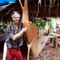
2018 and 2019 saw the discovery and excavation of four early colonial-era boats in New South Wale... more 2018 and 2019 saw the discovery and excavation of four early colonial-era boats in New South Wales (NSW), Australia, constructed of Australian hardwood timber. The ‘Barangaroo Boat’ was found in a terrestrial context during the construction of a new Sydney Metro station at Barangaroo, Sydney. The remains of the articulated clinker-built boat were methodically excavated, dismantled and stored until they entered the 3D recording and conservation program.
The ‘Windsor Boats’ are the partial, disarticulated remains of two clinker and one carvel-built vessels discovered in the Hawkesbury River during excavations of the banks to install scour protection for the Windsor Bridge replacement project by Transport for NSW. The timbers were stored on site until they too entered the 3D recording and conservation program.
This paper explores the value of 3D recording in shipwreck conservation. All timbers across both projects were recorded in 3D immediately after being unpacked and cleaned of surface debris, using the Annotated Scans Method – a combination of structured light scanning and Rhino3D software to produce individual 3D digital models with all physical features annotated in layers for interpretation and possible future reconstruction. This work was undertaken by maritime archaeologists and conservators. A portion of the assemblages will be re-scanned following the PEG-wax treatment and freeze-drying stage to determine possible warping and/or shrinkage effects of this conservation method on waterlogged Australian timber. It is the first time archaeological remains of Australian built vessels have been recorded in this way and undergone this treatment.

Sydney Historical Archaeology Practitioners' (SHAP) Workshop, 2023
During works by Sydney Metro on the new Barangaroo station, an early 19th century clinker-built b... more During works by Sydney Metro on the new Barangaroo station, an early 19th century clinker-built boat, constructed entirely of Australian timber species, was found. Following the excavation of the “Barangaroo Boat” in 2018, detailed 3D recording and conservation of the boat timbers began in October 2019. It is one of the earliest known watercraft from the early colonial period to be fully excavated, lifted, recorded and conserved in Australia.
The timbers were recorded using the newly developed “3D Annotated Scans Method” which uses a combination of image capture using a structured light scanner and an annotation phase of the 3D models using the CAD software, Rhino3D. This project represents the first use of this recording workflow in Australia, and it has provided capacity-building opportunities for the professional Australian heritage community.
The conservation method is a modified polyethylene glycol treatment plan, including a freeze-drying stage, incorporating lessons learned from historic shipwrecks treated in the Northern Hemisphere. Australian archaeological waterlogged timbers have not previously been treated using this methodology on this scale.
Over the last three and a half years, the application of methods developed for the recording and treatment of shipwreck timbers in the Northern Hemisphere, to the Australian context, has yielded valuable results that will serve as the baseline for Australian waterlogged timber artefacts into the future.
Australian Marine Sciences Association (AMSA) Conference, 2021
‘Breakers ahead!’ – Uncharted reef systems along the east and north-east coasts of Australia were... more ‘Breakers ahead!’ – Uncharted reef systems along the east and north-east coasts of Australia were a constant threat to shipping throughout the 19th century. The Silentworld Foundation, in collaboration with the Australian National Maritime Museum, has been investigating shipwreck events in this region since 2009. In 2017, following an expedition to Kenn Reefs in the Coral Sea, the field team noted that a dark discolouration along certain parts of the reef, as seen in satellite imagery, lined up exactly with the location of shipwreck sites. This phenomenon is known as ‘black reefs’ and is the result of an event whereby a coral-dominated system is replaced by brown coloured algae, due to the abundance of an otherwise limiting factor – in this case, iron from shipwrecks as old as 180 years. The team is now testing the viability of using the phenomenon as a predictive model for locating shipwrecks remotely. Furthermore, a range of data from the affected communities is being collected during expeditions, as this may reveal information on changes over time and, ultimately, on the ability of reef ecosystems to thrive under an alternate state.

During construction works by Sydney Metro on the new Barangaroo Station, an early 19th century co... more During construction works by Sydney Metro on the new Barangaroo Station, an early 19th century colonial boat was found, constructed entirely of Australian timber species. Following the excavation of the “Barangaroo Boat” in 2018, the detailed recording and conservation of the boat’s timbers began in October 2019. It is one of the earliest known watercraft from the early colonial period to be fully excavated, lifted, recorded and conserved in Australia. The timbers were recorded by the Silentworld Foundation team, following the “3D Annotated Scans Method”: they were first 3D scanned in high resolution using an Artec Eva structured-light scanner, and then annotated in 3D in the CAD software, Rhino.
This project represents the first use of this time- and cost-efficient recording workflow in Australia, and it has provided capacity-building for the Australian heritage community. This paper looks at the method as it was applied to the Barangaroo Boat recording project and explores the benefits, challenges faced and future uses of this data.

Australian Society for Historical Archaeology (ASHA) Conference, 2021
4min bottom time allowed on air before beginning the gradual ascent to the surface. 4min to archa... more 4min bottom time allowed on air before beginning the gradual ascent to the surface. 4min to archaeologically record a 19th century anchor clinging to an underwater cliff face of a remote coral reef in the middle of Torres Strait.
Doing archaeology underwater comes with the challenge of operating in an inhospitable environment. Maritime archaeologists have long relied on technological advances to allow them to work to professional standards. Two of these advances, digital photography and photogrammetric 3D reconstruction (P3DR), have revolutionised the speed and ease with which submerged cultural heritage can be accurately documented and disseminated to a professional and public audience. This paper explores a variety of scenarios in which the Silentworld Foundation and Australian National Maritime Museum have applied P3DR to capture data for the purposes of historic shipwreck analysis, interpretation and exhibition.
Society for Historical Archaeology (SHA) Conference, 2020
Satellite imagery has changed the approach to the search for shipwrecks in maritime archaeology. ... more Satellite imagery has changed the approach to the search for shipwrecks in maritime archaeology. The Geographic Information Systems (GIS) work undertaken by archaeologists, following the Silentworld Foundation and Australian National Maritime Museum collaborative expedition in 2017 to Kenn Reefs in the Coral Sea, revealed that shipwreck sites and their effect on coral reefs could be seen on appropriate satellite imagery as dark discolourations.
This predictive modelling was applied to the next scheduled expedition, which took place in December 2018. Satellite imagery of Boot Reef in the Torres Strait, was obtained and analysed for the same dark discolouration prior to commencement of the fieldwork. This produced a list of locations to be prioritised for investigation by magnetometer and snorkel teams. This paper outlines the results of the fieldwork and discusses the effectiveness of this application.
Society for Historical Archaeology (SHA) Conference, 2020
Since 1999, the Australian National Maritime Museum (ANMM) has worked with the Rhode Island Marin... more Since 1999, the Australian National Maritime Museum (ANMM) has worked with the Rhode Island Marine Archaeology Program (RIMAP) to search for the remains of Lord Sandwich, a British troop transport sunk in Newport Harbor during the American Revolution. Lord Sandwich is perhaps best known as the former HMB Endeavour, the vessel used by Lieutenant James Cook during his first voyage of exploration to the Pacific. In 2018, a shipwreck site in Newport Harbor was tentatively identified by RIMAP, ANMM and the Silentworld Foundation as Lord Sandwich/ex-HMB Endeavour. Due to poor water clarity, the team turned to the technique of Photogrammetric 3D Reconstruction (P3DR) to record the site. This paper will discuss the methods used to collect P3DR imagery during the 2018 investigations, and address how these data aided in the identification of a vessel whose voyage of exploration led to the European occupation of Australia.
Society for Historical Archaeology (SHA) Conference, 2020
In early 2018, a collaborative team comprising maritime archaeologists, museum specialists and vo... more In early 2018, a collaborative team comprising maritime archaeologists, museum specialists and volunteers from the South Australian Department for Environment and Water (DEW), South Australian Maritime Museum, Silentworld Foundation, Australian National Maritime Museum, MaP Fund and Flinders University surveyed for and located the shipwreck site of the barque South Australian. Lost at Rosetta Harbor (present-day Encounter Bay) South Australia in December 1837, South Australian is South Australia’s oldest documented shipwreck. Its significance also derives from its use as one of the earliest immigration ships to ferry European settlers to the colony of South Australia, as well as careers as a postal packet and ‘cutting-in’ vessel for shore-based whaling activities. This paper will discuss the effort to locate South Australian, as well as archaeological fieldwork that has taken place at the wreck site subsequent to its discovery.
Society for Historical Archaeology (SHA) Conference, 2020
HMAS Perth (I) was one of three modified Leander Class light cruisers commissioned into the Royal... more HMAS Perth (I) was one of three modified Leander Class light cruisers commissioned into the Royal Australian Navy shortly before the beginning of the Second World War. In February 1942 Perth, along with the heavy cruiser USS Houston, encountered a Japanese invasion fleet off the Indonesian island of Java. Both ships were sunk with heavy casualties. Perth was discovered by an Australian wreck diver in 1967 and over the next 30 years became a popular recreational and technical dive site. In late 2013, technical divers reported to the Australian Government that Perth was being targeted by commercial salvage activity. This paper examines the role of the Australian National Maritime Museum, Silentworld Foundation and Indonesia’s National Centre for Archaeology and Ministry of Marine Affairs and Fisheries to survey the site in 2016, 2017 and 2019. It also explores attempts to get the site protected under Indonesian cultural heritage law.
Society for Historical Archaeology (SHA) Conference, 2018
Archival research coupled with data from a collaborative expedition to Kenn Reefs, Australian Cor... more Archival research coupled with data from a collaborative expedition to Kenn Reefs, Australian Coral Sea Territory, undertaken by the Silentworld Foundation and Australian National Maritime Museum, have revealed the likely wreck site of mid-19th century convict transport vessel, Rodney. Over its lifetime Rodney transported hundreds of convicts and government passengers (free settlers) to Australia. It was one of many privately owned ships that undertook this work. However, these vessels did not only provide a means of physical, human transportation, they carried also the culture and ideas of these individuals, they became the links between ports of the British Empire globally and ultimately facilitated the development of Australia into the modern, multicultural place it is today. The paper focuses on this concept through the lens of a single ship as a representative example.
Society For Historical Archaeology (SHA) Conference, 2018
In 2017, maritime archaeologists from the Silentworld Foundation and Australian National Maritime... more In 2017, maritime archaeologists from the Silentworld Foundation and Australian National Maritime Museum conducted a survey of historic shipwreck sites at Kenn Reefs, Australian Coral Sea Territory. The acquired data was utilised to build a comprehensive Geographic Information System (GIS) project. Maritime archaeology was born of, and is continually improved by, technological advances. GIS has become yet another indispensible tool to the modern maritime archaeologist - integrating data ranging from GPS, satellite/aerial imagery, bathymetric surveys, contour lines and more, has never been easier. Physical recording of features on site is still required but there is much to be gained from combining layers of information (including scans of physical plans) to build an overall site picture. Presented here is a case study of the benefits (and downfalls) of GIS work as applied to the Kenn Reefs shipwreck survey, including the use of the results as a predictive model for future work.


Uploads
Papers by Irini Malliaros
Earlier this year, Kieran Hosty, Irini Malliaros and Julia Sumerling visited the site of Australia’s worst civil maritime disaster.
National Maritime Museum and Silentworld Foundation
recently led an expedition to the Australian Coral Sea
Territory to conduct an archaeological survey of historic
shipwrecks lost at Kenn Reefs during the 19th century.
James Hunter and Renee Malliaros report on their findings.
Conference Presentations by Irini Malliaros
The ‘Windsor Boats’ are the partial, disarticulated remains of two clinker and one carvel-built vessels discovered in the Hawkesbury River during excavations of the banks to install scour protection for the Windsor Bridge replacement project by Transport for NSW. The timbers were stored on site until they too entered the 3D recording and conservation program.
This paper explores the value of 3D recording in shipwreck conservation. All timbers across both projects were recorded in 3D immediately after being unpacked and cleaned of surface debris, using the Annotated Scans Method – a combination of structured light scanning and Rhino3D software to produce individual 3D digital models with all physical features annotated in layers for interpretation and possible future reconstruction. This work was undertaken by maritime archaeologists and conservators. A portion of the assemblages will be re-scanned following the PEG-wax treatment and freeze-drying stage to determine possible warping and/or shrinkage effects of this conservation method on waterlogged Australian timber. It is the first time archaeological remains of Australian built vessels have been recorded in this way and undergone this treatment.
The timbers were recorded using the newly developed “3D Annotated Scans Method” which uses a combination of image capture using a structured light scanner and an annotation phase of the 3D models using the CAD software, Rhino3D. This project represents the first use of this recording workflow in Australia, and it has provided capacity-building opportunities for the professional Australian heritage community.
The conservation method is a modified polyethylene glycol treatment plan, including a freeze-drying stage, incorporating lessons learned from historic shipwrecks treated in the Northern Hemisphere. Australian archaeological waterlogged timbers have not previously been treated using this methodology on this scale.
Over the last three and a half years, the application of methods developed for the recording and treatment of shipwreck timbers in the Northern Hemisphere, to the Australian context, has yielded valuable results that will serve as the baseline for Australian waterlogged timber artefacts into the future.
This project represents the first use of this time- and cost-efficient recording workflow in Australia, and it has provided capacity-building for the Australian heritage community. This paper looks at the method as it was applied to the Barangaroo Boat recording project and explores the benefits, challenges faced and future uses of this data.
Doing archaeology underwater comes with the challenge of operating in an inhospitable environment. Maritime archaeologists have long relied on technological advances to allow them to work to professional standards. Two of these advances, digital photography and photogrammetric 3D reconstruction (P3DR), have revolutionised the speed and ease with which submerged cultural heritage can be accurately documented and disseminated to a professional and public audience. This paper explores a variety of scenarios in which the Silentworld Foundation and Australian National Maritime Museum have applied P3DR to capture data for the purposes of historic shipwreck analysis, interpretation and exhibition.
This predictive modelling was applied to the next scheduled expedition, which took place in December 2018. Satellite imagery of Boot Reef in the Torres Strait, was obtained and analysed for the same dark discolouration prior to commencement of the fieldwork. This produced a list of locations to be prioritised for investigation by magnetometer and snorkel teams. This paper outlines the results of the fieldwork and discusses the effectiveness of this application.
Earlier this year, Kieran Hosty, Irini Malliaros and Julia Sumerling visited the site of Australia’s worst civil maritime disaster.
National Maritime Museum and Silentworld Foundation
recently led an expedition to the Australian Coral Sea
Territory to conduct an archaeological survey of historic
shipwrecks lost at Kenn Reefs during the 19th century.
James Hunter and Renee Malliaros report on their findings.
The ‘Windsor Boats’ are the partial, disarticulated remains of two clinker and one carvel-built vessels discovered in the Hawkesbury River during excavations of the banks to install scour protection for the Windsor Bridge replacement project by Transport for NSW. The timbers were stored on site until they too entered the 3D recording and conservation program.
This paper explores the value of 3D recording in shipwreck conservation. All timbers across both projects were recorded in 3D immediately after being unpacked and cleaned of surface debris, using the Annotated Scans Method – a combination of structured light scanning and Rhino3D software to produce individual 3D digital models with all physical features annotated in layers for interpretation and possible future reconstruction. This work was undertaken by maritime archaeologists and conservators. A portion of the assemblages will be re-scanned following the PEG-wax treatment and freeze-drying stage to determine possible warping and/or shrinkage effects of this conservation method on waterlogged Australian timber. It is the first time archaeological remains of Australian built vessels have been recorded in this way and undergone this treatment.
The timbers were recorded using the newly developed “3D Annotated Scans Method” which uses a combination of image capture using a structured light scanner and an annotation phase of the 3D models using the CAD software, Rhino3D. This project represents the first use of this recording workflow in Australia, and it has provided capacity-building opportunities for the professional Australian heritage community.
The conservation method is a modified polyethylene glycol treatment plan, including a freeze-drying stage, incorporating lessons learned from historic shipwrecks treated in the Northern Hemisphere. Australian archaeological waterlogged timbers have not previously been treated using this methodology on this scale.
Over the last three and a half years, the application of methods developed for the recording and treatment of shipwreck timbers in the Northern Hemisphere, to the Australian context, has yielded valuable results that will serve as the baseline for Australian waterlogged timber artefacts into the future.
This project represents the first use of this time- and cost-efficient recording workflow in Australia, and it has provided capacity-building for the Australian heritage community. This paper looks at the method as it was applied to the Barangaroo Boat recording project and explores the benefits, challenges faced and future uses of this data.
Doing archaeology underwater comes with the challenge of operating in an inhospitable environment. Maritime archaeologists have long relied on technological advances to allow them to work to professional standards. Two of these advances, digital photography and photogrammetric 3D reconstruction (P3DR), have revolutionised the speed and ease with which submerged cultural heritage can be accurately documented and disseminated to a professional and public audience. This paper explores a variety of scenarios in which the Silentworld Foundation and Australian National Maritime Museum have applied P3DR to capture data for the purposes of historic shipwreck analysis, interpretation and exhibition.
This predictive modelling was applied to the next scheduled expedition, which took place in December 2018. Satellite imagery of Boot Reef in the Torres Strait, was obtained and analysed for the same dark discolouration prior to commencement of the fieldwork. This produced a list of locations to be prioritised for investigation by magnetometer and snorkel teams. This paper outlines the results of the fieldwork and discusses the effectiveness of this application.