|
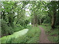
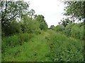
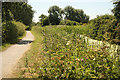
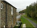
Former Thames & Severn Canal near South Cerney
by Malc McDonald
geograph for square SU0498
A path alongside the former Thames & Severn Canal near South Cerney in... (more)
|

|
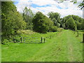
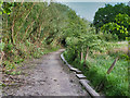
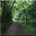
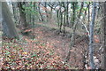
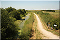
Former Thames & Severn Canal near South Cerney
by Malc McDonald
geograph for square SU0498
The former Thames & Severn Canal, now disused and overgrown, near South... (more)
|

|
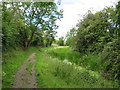
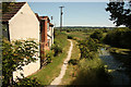
Former Thames & Severn Canal near South Cerney
by Malc McDonald
geograph for square SU0498
The former Thames & Severn Canal, now disused and overgrown.
The path... (more)
|
|
Former Thames & Severn Canal near South Cerney
by Malc McDonald
geograph for square SU0398
The route of the former Thames & Severn Canal near South Cerney in... (more)
|
|
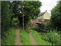
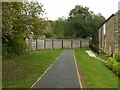
Thames & Severn Way near South Cerney
by Malc McDonald
geograph for square SU0498
This path alongside the former Thames & Severn Canal now forms part of the... (more)
|
|
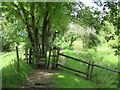
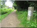
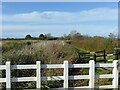
Stile near Siddington
by Malc McDonald
geograph for square SU0398
A stile on the Thames & Severn Way long distance path near Siddington in... (more)
|
|
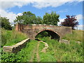
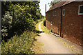
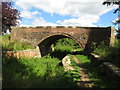
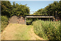
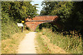
Cowground Bridge near Siddington
by Malc McDonald
geograph for square SU0399
Cowground Bridge crosses the disused Thames & Severn Canal near Siddington... (more)
|
|
Thames & Severn Canal near South Cerney
by Malc McDonald
geograph for square SU0797
The Thames & Severn Canal on the edge of the Cotswold Water Peak, near the... (more)
|

|
Thames & Severn Canal near Siddington
by Malc McDonald
geograph for square SU0398
The bed of the former Thames & Severn Canal in Gloucestershire countryside.... (more)
|
|
Thames & Severn Path near South Cerney
by Malc McDonald
geograph for square SU0797
The Thames & Severn Path passing along the edge of the Cotswold Water Park.... (more)
|
|
Towpath without a Canal
by David Dixon
geograph for square SD7909
This is/was part of the Manchester, Bolton and Bury Canal towpath. The canal... (more)
|
|
Towpath, Westport Canal, south from Westmoor Bridge
by Christine Johnstone
geograph for square ST4021
The former canal is on the right [east], the Westmoor catchwater drain on the left.
|

|
Grantham Canal towpath
by Richard Croft
geograph for square SK7634
Grassy towpath by the disused Grantham Canal near Plungar
|
|
Grantham Canal towpath
by Richard Croft
geograph for square SK7331
Fairview Cottage and the Grantham Canal towpath looking SW from Harby bridge
|
|
Cromford Canal north of Whatstandwell
by David Lally
geograph for square SK3354
|

|
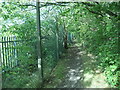
Bridleway notice alongside former canal towpath, Newport
by Jaggery
geograph for square ST2888
Former Monmouthshire & Brecon Canal (Crumlin arm) canal bridge number 4... (more)
|

|
Public footpath approaching Dearne Valley country park
by Christine Johnstone
geograph for square SE3506
Difficult to imagine, but this path is the route of the Dearne and Dove Canal... (more)
|
|
Public footpath, heading north from Pontefract Road, Barnsley
by Christine Johnstone
geograph for square SE3506
Difficult to imagine, but this path is the route of the Dearne and Dove Canal... (more)
|
|
Cowground Bridge near Siddington
by Malc McDonald
geograph for square SU0399
Cowground Bridge crosses the disused Thames & Severn Canal near Siddington... (more)
|
|
Grantham Canal
by Richard Croft
geograph for square SK6731
Towpath cycle route by the disused Grantham Canal
|

|
Westport Canal, north of Westmoor Bridge
by Christine Johnstone
geograph for square ST4021
The Westport Canal opened in 1840, linking Westport to the navigable River... (more)
|

|
Cromford Canal towpath footpath
by Alan Murray-Rust
geograph for square SK3552
This is the point at which the footpath traditionally left the course of the... (more)
|
|
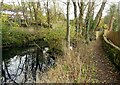
Cromford Canal at Bullbridge
by Alan Murray-Rust
geograph for square SK3552
This is the only remain section of the canal locally which still holds water.... (more)
|

|
Cromford Canal towpath footpath at Bullbridge
by Alan Murray-Rust
geograph for square SK3552
To the right is the area once occupied by the lime works served by the Butterley... (more)
|
|
Derelict section of canal, near Abercarn
by M J Roscoe
geograph for square ST2195
Dry section of the Crumlin Arm of the Mon & Brec Canal below the A467. A... (more)
|
|
Course of the Cromford Canal at Bullbridge 1
by Alan Murray-Rust
geograph for square SK3552
Passing through the housing development which has replaced the former Stevensons... (more)
|
|
Course of the Cromford Canal at Bullbridge 2
by Alan Murray-Rust
geograph for square SK3552
Looking back to the bridge carrying Bullbridge Hill over the canal. The canal... (more)
|
|
Grantham Canal near Hose
by Alan Murray-Rust
geograph for square SK7229
Looking west from Marriott's Bridge, no.38.
|
|
Bridge 46
by Richard Croft
geograph for square SK7533
Disused railway bridge over the disused Grantham Canal
|
|
Grantham Canal
by Richard Croft
geograph for square SK7229
View NW from Long Clawson Bridge along the disused Grantham Canal
|
|
Clarke's Bridge
by Richard Croft
geograph for square SK7029
Bridge 32 on the Grantham Canal for agricultural traffic
|

|
Devil's Elbow
by Richard Croft
geograph for square SK6631
A bend in the Grantham Canal known as Devil's Elbow
|
|
Grantham Canal
by Richard Croft
geograph for square SK7229
View east from Long Clawson Bridge
|
|
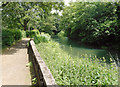
Path by the Ivel
by Des Blenkinsopp
geograph for square TL1844
The River Ivel was navigable years ago and quite a few stretches of what was... (more)
|