Papers by Rich Potter

Opuscula. Annual of the Swedish Institutes at Athens and Rome, 2022
This paper presents preliminary results of the Palamas Archaeological Project relating to the Lat... more This paper presents preliminary results of the Palamas Archaeological Project relating to the Late Roman and Early Byzantine periods in the study area in western Thessaly, Greece. These periods are comparatively understudied in Thessaly, and the aim of this work is to highlight the extent of the material and the potential of investigating the archaeology of Late Antiquity in the region. The work was centred on excavations and survey at the site at Vlochos, alongside architectural survey at the neighbouring site on Kourtikiano hill. The paper also presents studies into Late Roman and Early Byzantine material found during cleaning at Vlochos. Additionally, an unpublished inscription spoliated in a church in nearby Palamas is presented. The results show a dynamic and detailed range of Late Antique activity in the area, adding significantly to our understanding of the post-Classical habitations on the western Thessalian plain.
Med Hjarta Och Hjarna En Vanbok Till Professor Elisabeth Arwill Nordbladh, 2014

Journal of Archaeological Method and Theory, 2021
Rock art carvings, which are best described as petroglyphs, were produced by removing parts of th... more Rock art carvings, which are best described as petroglyphs, were produced by removing parts of the rock surface to create a negative relief. This tradition was particularly strong during the Nordic Bronze Age (1700-550 BC) in southern Scandinavia with over 20,000 boats and thousands of humans, animals, wagons, etc. This vivid and highly engaging material provides quantitative data of high potential to understand Bronze Age social structures and ideologies. The ability to provide the technically best possible documentation and to automate identification and classification of images would help to take full advantage of the research potential of petroglyphs in southern Scandinavia and elsewhere. We, therefore, attempted to train a model that locates and classifies image objects using faster region-based convolutional neural network (Faster-RCNN) based on data produced by a novel method to improve visualizing the content of 3D documentations. A newly created layer of 3D rock art documentation provides the best data currently available and has reduced inscribed bias compared to older methods. Several models were trained based on input images annotated with bounding boxes produced with different parameters to find the best solution. The data included 4305 individual images in 408 scans of rock art sites. To enhance the models and enrich the training data, we used data augmentation and transfer learning. The successful models perform exceptionally well on boats and circles, as well as with human figures and wheels. This work was an interdisciplinary undertaking which led to important reflections about archaeology, digital humanities, and artificial intelligence. The reflections and the success represented by the trained models open novel avenues for future research on rock art.

by Rich Potter, Helène Whittaker, Robin Rönnlund, Fotini Tsiouka, Johan Klange, Derek Pitman, Lawrence Shaw, Ellen Siljedahl, Sujatha Chandrasekaran / Суджата Чандрасекаран, Asta Pavilionytė, Hayden Scott-Pratt, Elisabet Schager, Harry Manley, and Josephine Hagan Opuscula Annual of the Swedish Institutes at Athens and Rome, 2020
The Vlochos Archaeological Project (2016–2018) was a Greek-Swedish archaeological investigation o... more The Vlochos Archaeological Project (2016–2018) was a Greek-Swedish archaeological investigation of the remains of the ancient urban site at Vlochos in western Thessaly, Greece. Employing a wide array of non-invasive methods, the project succeeded in completely mapping the visible remains, which had previously not been systematically investigated. The extensive remains of multi-period urban fortifications, a Classical-Hellenistic city, a Roman town, and a Late Antique fortress were identified, evidence of the long history of habitation on this site. Since comparatively little fieldwork has been conducted in the region, the results significantly increase our knowledge of the history and archaeology of Thessaly.
Fornvännen, 2019
This paper presents the results of a recent documentation of the rock art panel called “Runohälle... more This paper presents the results of a recent documentation of the rock art panel called “Runohällen” in Gerum, Bohuslän (RAÄ Tanum 311:1). The documentation was conducted using photogrammetry and analysed using a new documentation method. It was possible to identify several new motifs, updating the record from previous documentations. During this work a petroglyph previously identified as an axe stood out through an elongated and as of yet unexplained feature. It is argued that this motif is indeed an axe, but converse to the older interpretation, it is suggested that the motif is turned “upside-down” when compared to the majority of petroglyphs on the panel. Several interpretations are considered, but it is thought most likely that the carving had an antagonistic purpose.

The Bredarör cairn in Kivik sparked the interest of researchers by presenting the rare combinatio... more The Bredarör cairn in Kivik sparked the interest of researchers by presenting the rare combination of rock art within a burial con- text. A recent documentation project that employed the traditional tracing method has sparked a new debate about the precision of older tracings and frottages. This paper presents the results of a holistic recording of the slabs in the Bredarör cairn using three modern methods: Structure from Motion (SfM), Optical Laser Scanning (OLS) and Reflectance Transformation Imaging (RTI).
In discussing SfM, OLS and RTI, the paper demonstrates the power of these tools to expand the capabilities to record rock art in an unbiased fashion and in greater detail. In contrast to older methods, the depth and texture of features on the rock are documented and human error is reduced, because everything is recorded.
Some observations of the earlier documentation efforts were confirmed, and more details added, such as information on ship prows and horse design. This allowed an in-depth discussion of the dating and use of rock art in the Bredarör cairn. It is argued that although there is evidence that the slabs were transformed several times, the majority of the carving activity was carried out during Period II of the Nordic Bronze Age. It suggests that an important individual, possibly connected to long-distance trade, was interred in the cairn that subsequently served as a necropolis until the Late Bronze Age.

Journal of Archaeological Science: Reports, 2019
Rock art provides a tangible visual link to past communities and has significant value in buildin... more Rock art provides a tangible visual link to past communities and has significant value in building our understanding of prehistoric societies. Its recording and interpretation has long provided a window to intangible aspects of society, such as belief systems and folk narratives. Petroglyphic rock art has traditionally been recorded through simple rubbing, or frottage, and the majority of interpretations and narratives to date have been based on this work. Recently, three-dimensional capture techniques have become readily available and they replace traditional approaches to rock art recording. These techniques are valuable, but the data-heavy outputs lack the interpretive clarity of traditional methods. This paper explores these issues through a novel approach that employs topographic landscape analysis techniques, initially developed for LiDAR processing, to produce clear images that have the precision and dimensional accuracy of 3D captured data, but the visual clarity of traditional methods. Specifically, this paper outlines an approach based on local relief modelling (a technique that highlights subtle topographic features) and explores its efficacy through case studies of Bronze Age Scandinavian petroglyphs. This method was developed to aid the analysis of 3D models and to improve vi-sualising the results based on such investigations. This work offers a significant impact on rock art studies as it facilitates the identification of previously unidentified motifs, and allows a clearer sense of petroglyphic world views. The technique can be applied to models of other archaeological surfaces.

European Journal of Archaeology, 2017
Human representations are one of the most important groups of depictions in rock art in southern ... more Human representations are one of the most important groups of depictions in rock art in southern Scandinavia. These humans have long been discussed as complete, stable, and temporally-fixed images. The results of a new survey challenge this view. Recording rock art with Reflectance Transformation Imaging (RTI) enabled us to discern a possible sequence of production of individual human representations , their bodily features, and associated objects. Figures from a rock art site in Finntorp (Tanum, Sweden) will be used as an example. Differences in the dimensions of the engraved lines, the chronology of the depicted objects, and the placement of body parts suggest that several individuals may have been involved in making human representations on the rocks, and that their appearance as complete figures is the result of repeated transformations. The results presented demonstrate that Scandinavian rock art is not stable in time. We suggest that rock art is best understood as the creation of communities over time, which enables them to engage with the past by transforming the rocks.

Open Archaeology, 2018
Southern Scandinavia is Europe's richest region in terms of figurative rock art. It is imperative... more Southern Scandinavia is Europe's richest region in terms of figurative rock art. It is imperative to document this cultural heritage for future generations. To achieve this, researchers need to use the most objective recording methods available in order to eliminate human error and bias in the documentation. The ability to collect more data is better, not only for documentation, but also for research purposes. Recent years have seen the wider introduction of image based 2.5D and 3D modelling of rock art surfaces. These methods are Reflectance Transformation Imaging (RTI), Structure from Motion (SfM), and Optical Laser Scanning (OLS). Importantly, these approaches record depth difference and the structure of engraved lines. Therefore, they have clear advantages over older methods such as frottage (rubbings) and tracing. Based on a number of short case studies, this paper argues that 2.5D and 3D methods should be used as a standard documentation techniques, but not in an exclusionary manner. The best documentation, enabling preservation and high-quality research, should employ all methods. Approaching rock art with all the research tools available we can re-appraise older documentation as well as investigate individual action and the transformation of rock art.

Engraving of Gothenburg from the 17 th Century Wireframe of Karlsporten superimposed on the plan.... more Engraving of Gothenburg from the 17 th Century Wireframe of Karlsporten superimposed on the plan. Examples from the process of modelling Karlsporten Examples of the source material T03S006 Further models reconstructed for the project A A A A A A A An n n n n n nd d d d d d d dr r r r ri i i i in n n ne e e e N N N N N Ni i i i il l l ls s se e e e en n n n n n, , , , P P P P P P Ph h h hD D D S S S St t t tu u ud d d d de en n n nt t t t t ---G G G G G G Go o o o o ot t t t th h h h h h he e e e e e en n n n nb b b b b b b bu u u u u ur r r r rg g g g g g g U U U U U U U U Un n n n ni i i iv v v ve e e e e e er r r rs s si i i i i it t t t t ty y y y y ---a a a a an n n nd d d d d dr r r r ri i i i i in n n n ne e e e. . . .n n n ni i i il l l l ls s s se e e e e en n n@ @ @g gu u u. . .s s s s se e e e --R R R R R R Ri i i i ic c c c c ch h h h h P P P P Po o o ot t t t t tt t t te e e er r r r r r, , , , , B B B B B B BA A A A A ---r r r r ri i i ic c ch h h h h h ha a a a a a ar r r r r r r r r rd d d d d d d d d. . .p p p p p p p po o o o o ot t t t tt t te e e er r r r r@ @ @ @ @ @g g g g g gu u u u u. .s s s s se e e e e

ARCHITECTURE, ARCHAEOLOGY AND CONTEMPORARY CITY PLANNING, 2014
This project aims to achieve a fuller picture of how the city of Gothenburg may have looked
in 1... more This project aims to achieve a fuller picture of how the city of Gothenburg may have looked
in 1698 through collaborative research and digital visualization techniques. We aim to bring life to the
research by asking questions like: why did the streets lean? Were all the urban plots in use? In what
sort of dwellings did the people of Gothenburg live? Where was the pharmacist and which pub did
people attend? And why wasn’t the street at the top of Kvarnberget assigned a name? Answers to these
questions and more are found through research into the City Archives, the War Archives, publications
from historians as well as contemporary descriptions and imagery. This is combined with archaeological
reports, surviving buildings from the 17th century and city plans. Little by little the puzzle can be put
together in a 3D visualisation.
One of the main aspects of the project is to display the sources of the research and how to best convey
the research that has led to each aspect of the town being reconstructed as it is. This will be carried out
in a variety of methods including web deployment and the use of Unreal / Unity.
The results from different rendering techniques will be shown in this article and briefly discuss... more The results from different rendering techniques will be shown in this article and briefly discussed with regard to investigations of the pictorial surface on three picture stones from Gotland, Sweden. The island is the largest in the Baltic Sea and is well-known for its very rich and outstanding archaeological material, especially from the Viking Age and Early Medieval period. The picture stones that are the case studies for this article originate from three different sites on Gotland: Fröjel Bottarve, Fröjel Stenstugu and Buttle Änge. All of these sites are located in rural areas with rich agricultural lands and an abundance of ancient remains that speak of habitation and land use since at least the Bronze Age to present day. Fröjel Stenstugu and Buttle Änge are still standing at their original sites while Fröjel Bottarve was found re-used in a grave.
The aim of this paper is to examine the use of 3D in the field of archaeology and visually recons... more The aim of this paper is to examine the use of 3D in the field of archaeology and visually reconstruct an element from Norrköping's history through the medium of 3D Modelling
and Rendering.
The process will use the latest in 3D technology to reconstruct as accurate as possible imagery which can be used in the wider context of visualising historic scenes relating to Norrköping's history. The primary software that will be used for 3D modelling will be Lightwave 9.6, texturing will be carried out in Lightwave but augmented with Photoshop to create a more accurate and realistic feel than procedural texturing alone can create.
The final renders will be created in Vue 9 Infinite, as this has the best lighting scheme of the three.

This paper examines how culture and identity have been represented in museums in the past and pre... more This paper examines how culture and identity have been represented in museums in the past and present. It has examined the concepts of social culture, material culture and identity and discussed how they can be displayed in a museum environment and how exhibits can be affected by a patrons own personal beliefs.
There is discussion about how culture could best be represented in a museum given the fact that it is impossible to remove something so embodied as a patrons own culture and identity. It became apparent that one of the most acceptable ways of creating an interaction with other cultures was for the patrons were able to have a social encounter with the museum exhibit. This would be backed up by hands-on activities and social interaction with people working in the museum, with the tactile signifiers sight, sound, smell and touch creating an embodied
experience.
The design of the museum itself was also deemed to be a useful method of interaction to help convince the patron subconsciously that he was in fact travelling back to the age of the exhibit and that he was actually visiting another culture and preparing for an encounter. This would be achieved by creating a "time-line" from the entrance of the museum to various exhibits.
It became apparent that the best way for patrons to interactively experience culture in a museum environment was to create a physical encounter with the culture through the use of reconstruction and well informed actors. This would allow for the patrons to discover the identity and aspects of the culture of the subjects in the exhibit organically, ands also allow for more dialogue than static
displays, which would lead in turn to a more in depth experience and create a
more emphatic exhibit. This should cause patrons to emphasise more with the
culture, while helping to removing pre-conceived ideas that the patrons may have.

This report describes an investigation into the difficulties that Bronze Age people may have enco... more This report describes an investigation into the difficulties that Bronze Age people may have encountered and had to overcome during the construction and use of a Beehive Hearth Structure.
The work comprised a paper study of the hearth structures at the Százhalombatta Fölvár site in Hungary, followed by the experimental reconstruction of a Beehive structure in the UK.
The results of the investigation allowed a number of inferences to be made.
i) Key problem areas when building a Beehive kiln are likely to be connected with the method of construction used, in particular the frame, the mixture of daub and the weather conditions. From this it is inferred that the structures would most likely have been built in late summer or early autumn when ambient temperatures would have allowed the structure to dry fully before firing.
ii) It is most likely that cattle manure would have been used to make the daub rather than horse manure because of the small number of horse bones found at the site. In addition, cattle would have been used for for traction whilst collecting the large amounts of clay required for even such small constructions
iii) It was unlikely that the Beehive structures in the context of the site location would have been used for firing pottery in an oxidizing firing due to their proximity to surrounding walls.
iv) A review of possible uses for the hearth structures at the site suggested that Beehive and Updraft structures were primarily used for cooking while Fireplaces were used for heat and warmth with the possibility of the outside fireplace being used as a pottery firing bonfire.
Conference Presentations by Rich Potter
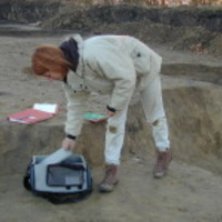
The archaeological site of Vlochós is located on and immediately below the hill of Strongilovoúni... more The archaeological site of Vlochós is located on and immediately below the hill of Strongilovoúni (313 masl) just south of the eponymous village in Thessaly, Greece. The Greek-Swedish collaboration ‘The Vlochos Archaeological Project’ (VLAP) was carried out between 2016 and 2018, with participating archaeologists and students from the Ephorate of Antiquities of Karditsa, the University of Gothenburg and Bournemouth University. The project was non-invasive, employing a wide arrange of methods in surveying the site, including surface survey of standing architectural remains, topographical surveying and geophysical prospection.
During a total of seven weeks of fieldwork, 6 km of fortification walls and terraces were recorded and 13 hectares of ground were surveyed using fluxgate-gradiometry. An additional 2.6 hectares of ground were surveyed using ground-penetrating radar (GPR), aiming at providing high-resolution “windows” into the buried remains on site. Most of the site surface was also photographed by a drone, providing the project with high-resolution vertical images of all visible remains. The photographs have been combined into a site-encompassing aerial mosaic, but also into a photogrammetric 3D model.
The work presented here focuses on the gradiometry survey that revealed an extensive urban layout that featured multiple phases of construction. Some of these can be dated confidently on the basis of stylistic elements and surface material, whereas some can only be chronologically positioned in relation to the others.
The extensive gradiometry, executed using a Bartington Grad601-2 gradiometer, covered a low plateau at the base of the fortified hill. The plateau is bounded to the north by the hill and to the south by a river. While some standing remains are visible, the area is largely covered by a layer of sediment and erosion deposits. This survey clearly revealed buried architecture, identified by low magnetic linear features, and areas of magnetic enrichment. In comparing this data with similar, excavated sites it is possible to postulate about the likely character of responses. Clear built structures are visible, some of which corresponding to Ancient Greek forms such as domestic houses, agorai, temples and stoai. Additionally, areas of magnetic enrichment focus on spaces between buildings and likely represent the remains of streets and avenues. Clear phasing can be seen in the differential orientation of street layouts and of some of the defensive structures.
The magnetic image can clearly be divided in two two phases, one which corresponds to the preserved late Classical and Hellenistic fortifications (mid-4th to early 2nd century BCE) and another that seemingly occurred later, most likely Late Roman (mid-6th century CE). Within the late Classical-Hellenistic phase there is a clear central avenue, running southeast-northwest, with numerous perpendicular streets that demarcate habitation blocks and other civic structures. The later phase of fortification shows hints of truncation of the earlier layout, most notably in the area immediately adjacent to the later wall. In addition, both phases include numerous entrances and towers.
A central tenant of the project is the incorporation of multiple non-invasive approaches. When the geophysical evidence is incorporated with the other techniques it becomes possible to propose a preliminary phase schema for the site.
The Vlochos Archaeological Project (VLAP) is a three-year collaboration between the Ephorate of A... more The Vlochos Archaeological Project (VLAP) is a three-year collaboration between the Ephorate of Antiquities of Karditsa and the Swedish Institute at Athens, involving a team of archaeologists from Greece, Sweden and the United Kingdom. The focus of the programme is the archaeological site at the modern village Vlochos, in the municipality of Palamas (prefecture of Karditsa); a fortified urban site of the Classical-Roman periods known from previous archaeological work in the region.
The objective of VLAP is to record the totality of the visible ancient structures as well as to conduct a geophysical survey of the buried remains, aiming at understanding the diachronic use of the site and its phases of habitation. Consequently, the data will contribute to a broader understanding of the urbanisation processes in this part of ancient western Thessaly. The programme is fully non-invasive, utilising both traditional documentation as well as modern digital methods of surveying.
The preliminary results of the first two field-seasons indicate that the remains at Vlochos belong to several chronologically distinct urban-like settlements, covering the late Classical period until Late Roman period. With parallels in both Thessaly and Boeotia, the site displays several characteristics of ancient urban environments in Central Greece, linking it with the general socio-political developments in the region.

This project aims to achieve a fuller picture of how the city of Gothenburg may have looked
in 1... more This project aims to achieve a fuller picture of how the city of Gothenburg may have looked
in 1698 through collaborative research and digital visualization techniques. We aim to bring life to the
research by asking questions like: why did the streets lean? Were all the urban plots in use? In what
sort of dwellings did the people of Gothenburg live? Where was the pharmacist and which pub did
people attend? And why wasn’t the street at the top of Kvarnberget assigned a name? Answers to these
questions and more are found through research into the City Archives, the War Archives, publications
from historians as well as contemporary descriptions and imagery. This is combined with archaeological
reports, surviving buildings from the 17th century and city plans. Little by little the puzzle can be put
together in a 3D visualisation.
One of the main aspects of the project is to display the sources of the research and how to best convey
the research that has led to each aspect of the town being reconstructed as it is. This will be carried out
in a variety of methods including web deployment and the use of Unreal / Unity.
Teaching Documents by Rich Potter
Apply here!
https://www.universityadmissions.se/intl/search?period=10&freeText=ae1042


Uploads
Papers by Rich Potter
In discussing SfM, OLS and RTI, the paper demonstrates the power of these tools to expand the capabilities to record rock art in an unbiased fashion and in greater detail. In contrast to older methods, the depth and texture of features on the rock are documented and human error is reduced, because everything is recorded.
Some observations of the earlier documentation efforts were confirmed, and more details added, such as information on ship prows and horse design. This allowed an in-depth discussion of the dating and use of rock art in the Bredarör cairn. It is argued that although there is evidence that the slabs were transformed several times, the majority of the carving activity was carried out during Period II of the Nordic Bronze Age. It suggests that an important individual, possibly connected to long-distance trade, was interred in the cairn that subsequently served as a necropolis until the Late Bronze Age.
in 1698 through collaborative research and digital visualization techniques. We aim to bring life to the
research by asking questions like: why did the streets lean? Were all the urban plots in use? In what
sort of dwellings did the people of Gothenburg live? Where was the pharmacist and which pub did
people attend? And why wasn’t the street at the top of Kvarnberget assigned a name? Answers to these
questions and more are found through research into the City Archives, the War Archives, publications
from historians as well as contemporary descriptions and imagery. This is combined with archaeological
reports, surviving buildings from the 17th century and city plans. Little by little the puzzle can be put
together in a 3D visualisation.
One of the main aspects of the project is to display the sources of the research and how to best convey
the research that has led to each aspect of the town being reconstructed as it is. This will be carried out
in a variety of methods including web deployment and the use of Unreal / Unity.
and Rendering.
The process will use the latest in 3D technology to reconstruct as accurate as possible imagery which can be used in the wider context of visualising historic scenes relating to Norrköping's history. The primary software that will be used for 3D modelling will be Lightwave 9.6, texturing will be carried out in Lightwave but augmented with Photoshop to create a more accurate and realistic feel than procedural texturing alone can create.
The final renders will be created in Vue 9 Infinite, as this has the best lighting scheme of the three.
There is discussion about how culture could best be represented in a museum given the fact that it is impossible to remove something so embodied as a patrons own culture and identity. It became apparent that one of the most acceptable ways of creating an interaction with other cultures was for the patrons were able to have a social encounter with the museum exhibit. This would be backed up by hands-on activities and social interaction with people working in the museum, with the tactile signifiers sight, sound, smell and touch creating an embodied
experience.
The design of the museum itself was also deemed to be a useful method of interaction to help convince the patron subconsciously that he was in fact travelling back to the age of the exhibit and that he was actually visiting another culture and preparing for an encounter. This would be achieved by creating a "time-line" from the entrance of the museum to various exhibits.
It became apparent that the best way for patrons to interactively experience culture in a museum environment was to create a physical encounter with the culture through the use of reconstruction and well informed actors. This would allow for the patrons to discover the identity and aspects of the culture of the subjects in the exhibit organically, ands also allow for more dialogue than static
displays, which would lead in turn to a more in depth experience and create a
more emphatic exhibit. This should cause patrons to emphasise more with the
culture, while helping to removing pre-conceived ideas that the patrons may have.
The work comprised a paper study of the hearth structures at the Százhalombatta Fölvár site in Hungary, followed by the experimental reconstruction of a Beehive structure in the UK.
The results of the investigation allowed a number of inferences to be made.
i) Key problem areas when building a Beehive kiln are likely to be connected with the method of construction used, in particular the frame, the mixture of daub and the weather conditions. From this it is inferred that the structures would most likely have been built in late summer or early autumn when ambient temperatures would have allowed the structure to dry fully before firing.
ii) It is most likely that cattle manure would have been used to make the daub rather than horse manure because of the small number of horse bones found at the site. In addition, cattle would have been used for for traction whilst collecting the large amounts of clay required for even such small constructions
iii) It was unlikely that the Beehive structures in the context of the site location would have been used for firing pottery in an oxidizing firing due to their proximity to surrounding walls.
iv) A review of possible uses for the hearth structures at the site suggested that Beehive and Updraft structures were primarily used for cooking while Fireplaces were used for heat and warmth with the possibility of the outside fireplace being used as a pottery firing bonfire.
Conference Presentations by Rich Potter
During a total of seven weeks of fieldwork, 6 km of fortification walls and terraces were recorded and 13 hectares of ground were surveyed using fluxgate-gradiometry. An additional 2.6 hectares of ground were surveyed using ground-penetrating radar (GPR), aiming at providing high-resolution “windows” into the buried remains on site. Most of the site surface was also photographed by a drone, providing the project with high-resolution vertical images of all visible remains. The photographs have been combined into a site-encompassing aerial mosaic, but also into a photogrammetric 3D model.
The work presented here focuses on the gradiometry survey that revealed an extensive urban layout that featured multiple phases of construction. Some of these can be dated confidently on the basis of stylistic elements and surface material, whereas some can only be chronologically positioned in relation to the others.
The extensive gradiometry, executed using a Bartington Grad601-2 gradiometer, covered a low plateau at the base of the fortified hill. The plateau is bounded to the north by the hill and to the south by a river. While some standing remains are visible, the area is largely covered by a layer of sediment and erosion deposits. This survey clearly revealed buried architecture, identified by low magnetic linear features, and areas of magnetic enrichment. In comparing this data with similar, excavated sites it is possible to postulate about the likely character of responses. Clear built structures are visible, some of which corresponding to Ancient Greek forms such as domestic houses, agorai, temples and stoai. Additionally, areas of magnetic enrichment focus on spaces between buildings and likely represent the remains of streets and avenues. Clear phasing can be seen in the differential orientation of street layouts and of some of the defensive structures.
The magnetic image can clearly be divided in two two phases, one which corresponds to the preserved late Classical and Hellenistic fortifications (mid-4th to early 2nd century BCE) and another that seemingly occurred later, most likely Late Roman (mid-6th century CE). Within the late Classical-Hellenistic phase there is a clear central avenue, running southeast-northwest, with numerous perpendicular streets that demarcate habitation blocks and other civic structures. The later phase of fortification shows hints of truncation of the earlier layout, most notably in the area immediately adjacent to the later wall. In addition, both phases include numerous entrances and towers.
A central tenant of the project is the incorporation of multiple non-invasive approaches. When the geophysical evidence is incorporated with the other techniques it becomes possible to propose a preliminary phase schema for the site.
The objective of VLAP is to record the totality of the visible ancient structures as well as to conduct a geophysical survey of the buried remains, aiming at understanding the diachronic use of the site and its phases of habitation. Consequently, the data will contribute to a broader understanding of the urbanisation processes in this part of ancient western Thessaly. The programme is fully non-invasive, utilising both traditional documentation as well as modern digital methods of surveying.
The preliminary results of the first two field-seasons indicate that the remains at Vlochos belong to several chronologically distinct urban-like settlements, covering the late Classical period until Late Roman period. With parallels in both Thessaly and Boeotia, the site displays several characteristics of ancient urban environments in Central Greece, linking it with the general socio-political developments in the region.
in 1698 through collaborative research and digital visualization techniques. We aim to bring life to the
research by asking questions like: why did the streets lean? Were all the urban plots in use? In what
sort of dwellings did the people of Gothenburg live? Where was the pharmacist and which pub did
people attend? And why wasn’t the street at the top of Kvarnberget assigned a name? Answers to these
questions and more are found through research into the City Archives, the War Archives, publications
from historians as well as contemporary descriptions and imagery. This is combined with archaeological
reports, surviving buildings from the 17th century and city plans. Little by little the puzzle can be put
together in a 3D visualisation.
One of the main aspects of the project is to display the sources of the research and how to best convey
the research that has led to each aspect of the town being reconstructed as it is. This will be carried out
in a variety of methods including web deployment and the use of Unreal / Unity.
Teaching Documents by Rich Potter
In discussing SfM, OLS and RTI, the paper demonstrates the power of these tools to expand the capabilities to record rock art in an unbiased fashion and in greater detail. In contrast to older methods, the depth and texture of features on the rock are documented and human error is reduced, because everything is recorded.
Some observations of the earlier documentation efforts were confirmed, and more details added, such as information on ship prows and horse design. This allowed an in-depth discussion of the dating and use of rock art in the Bredarör cairn. It is argued that although there is evidence that the slabs were transformed several times, the majority of the carving activity was carried out during Period II of the Nordic Bronze Age. It suggests that an important individual, possibly connected to long-distance trade, was interred in the cairn that subsequently served as a necropolis until the Late Bronze Age.
in 1698 through collaborative research and digital visualization techniques. We aim to bring life to the
research by asking questions like: why did the streets lean? Were all the urban plots in use? In what
sort of dwellings did the people of Gothenburg live? Where was the pharmacist and which pub did
people attend? And why wasn’t the street at the top of Kvarnberget assigned a name? Answers to these
questions and more are found through research into the City Archives, the War Archives, publications
from historians as well as contemporary descriptions and imagery. This is combined with archaeological
reports, surviving buildings from the 17th century and city plans. Little by little the puzzle can be put
together in a 3D visualisation.
One of the main aspects of the project is to display the sources of the research and how to best convey
the research that has led to each aspect of the town being reconstructed as it is. This will be carried out
in a variety of methods including web deployment and the use of Unreal / Unity.
and Rendering.
The process will use the latest in 3D technology to reconstruct as accurate as possible imagery which can be used in the wider context of visualising historic scenes relating to Norrköping's history. The primary software that will be used for 3D modelling will be Lightwave 9.6, texturing will be carried out in Lightwave but augmented with Photoshop to create a more accurate and realistic feel than procedural texturing alone can create.
The final renders will be created in Vue 9 Infinite, as this has the best lighting scheme of the three.
There is discussion about how culture could best be represented in a museum given the fact that it is impossible to remove something so embodied as a patrons own culture and identity. It became apparent that one of the most acceptable ways of creating an interaction with other cultures was for the patrons were able to have a social encounter with the museum exhibit. This would be backed up by hands-on activities and social interaction with people working in the museum, with the tactile signifiers sight, sound, smell and touch creating an embodied
experience.
The design of the museum itself was also deemed to be a useful method of interaction to help convince the patron subconsciously that he was in fact travelling back to the age of the exhibit and that he was actually visiting another culture and preparing for an encounter. This would be achieved by creating a "time-line" from the entrance of the museum to various exhibits.
It became apparent that the best way for patrons to interactively experience culture in a museum environment was to create a physical encounter with the culture through the use of reconstruction and well informed actors. This would allow for the patrons to discover the identity and aspects of the culture of the subjects in the exhibit organically, ands also allow for more dialogue than static
displays, which would lead in turn to a more in depth experience and create a
more emphatic exhibit. This should cause patrons to emphasise more with the
culture, while helping to removing pre-conceived ideas that the patrons may have.
The work comprised a paper study of the hearth structures at the Százhalombatta Fölvár site in Hungary, followed by the experimental reconstruction of a Beehive structure in the UK.
The results of the investigation allowed a number of inferences to be made.
i) Key problem areas when building a Beehive kiln are likely to be connected with the method of construction used, in particular the frame, the mixture of daub and the weather conditions. From this it is inferred that the structures would most likely have been built in late summer or early autumn when ambient temperatures would have allowed the structure to dry fully before firing.
ii) It is most likely that cattle manure would have been used to make the daub rather than horse manure because of the small number of horse bones found at the site. In addition, cattle would have been used for for traction whilst collecting the large amounts of clay required for even such small constructions
iii) It was unlikely that the Beehive structures in the context of the site location would have been used for firing pottery in an oxidizing firing due to their proximity to surrounding walls.
iv) A review of possible uses for the hearth structures at the site suggested that Beehive and Updraft structures were primarily used for cooking while Fireplaces were used for heat and warmth with the possibility of the outside fireplace being used as a pottery firing bonfire.
During a total of seven weeks of fieldwork, 6 km of fortification walls and terraces were recorded and 13 hectares of ground were surveyed using fluxgate-gradiometry. An additional 2.6 hectares of ground were surveyed using ground-penetrating radar (GPR), aiming at providing high-resolution “windows” into the buried remains on site. Most of the site surface was also photographed by a drone, providing the project with high-resolution vertical images of all visible remains. The photographs have been combined into a site-encompassing aerial mosaic, but also into a photogrammetric 3D model.
The work presented here focuses on the gradiometry survey that revealed an extensive urban layout that featured multiple phases of construction. Some of these can be dated confidently on the basis of stylistic elements and surface material, whereas some can only be chronologically positioned in relation to the others.
The extensive gradiometry, executed using a Bartington Grad601-2 gradiometer, covered a low plateau at the base of the fortified hill. The plateau is bounded to the north by the hill and to the south by a river. While some standing remains are visible, the area is largely covered by a layer of sediment and erosion deposits. This survey clearly revealed buried architecture, identified by low magnetic linear features, and areas of magnetic enrichment. In comparing this data with similar, excavated sites it is possible to postulate about the likely character of responses. Clear built structures are visible, some of which corresponding to Ancient Greek forms such as domestic houses, agorai, temples and stoai. Additionally, areas of magnetic enrichment focus on spaces between buildings and likely represent the remains of streets and avenues. Clear phasing can be seen in the differential orientation of street layouts and of some of the defensive structures.
The magnetic image can clearly be divided in two two phases, one which corresponds to the preserved late Classical and Hellenistic fortifications (mid-4th to early 2nd century BCE) and another that seemingly occurred later, most likely Late Roman (mid-6th century CE). Within the late Classical-Hellenistic phase there is a clear central avenue, running southeast-northwest, with numerous perpendicular streets that demarcate habitation blocks and other civic structures. The later phase of fortification shows hints of truncation of the earlier layout, most notably in the area immediately adjacent to the later wall. In addition, both phases include numerous entrances and towers.
A central tenant of the project is the incorporation of multiple non-invasive approaches. When the geophysical evidence is incorporated with the other techniques it becomes possible to propose a preliminary phase schema for the site.
The objective of VLAP is to record the totality of the visible ancient structures as well as to conduct a geophysical survey of the buried remains, aiming at understanding the diachronic use of the site and its phases of habitation. Consequently, the data will contribute to a broader understanding of the urbanisation processes in this part of ancient western Thessaly. The programme is fully non-invasive, utilising both traditional documentation as well as modern digital methods of surveying.
The preliminary results of the first two field-seasons indicate that the remains at Vlochos belong to several chronologically distinct urban-like settlements, covering the late Classical period until Late Roman period. With parallels in both Thessaly and Boeotia, the site displays several characteristics of ancient urban environments in Central Greece, linking it with the general socio-political developments in the region.
in 1698 through collaborative research and digital visualization techniques. We aim to bring life to the
research by asking questions like: why did the streets lean? Were all the urban plots in use? In what
sort of dwellings did the people of Gothenburg live? Where was the pharmacist and which pub did
people attend? And why wasn’t the street at the top of Kvarnberget assigned a name? Answers to these
questions and more are found through research into the City Archives, the War Archives, publications
from historians as well as contemporary descriptions and imagery. This is combined with archaeological
reports, surviving buildings from the 17th century and city plans. Little by little the puzzle can be put
together in a 3D visualisation.
One of the main aspects of the project is to display the sources of the research and how to best convey
the research that has led to each aspect of the town being reconstructed as it is. This will be carried out
in a variety of methods including web deployment and the use of Unreal / Unity.