

Okinawa Island
This article needs additional citations for verification. (January 2012) |
 | |
| Geography | |
|---|---|
| Location | Pacific Ocean |
| Coordinates | 26°30′N 127°56′E / 26.500°N 127.933°E |
| Archipelago | Okinawa Islands |
| Area | 1,201.03 km2 (463.72 sq mi) |
| Administration | |
Japan | |
| Demographics | |
| Population | 1,384,762 |
| Pop. density | 1,015.79/km2 (2630.88/sq mi) |
Okinawa Island (沖縄本島, Okinawa-hontō, alternatively 沖縄島 Okinawa-jima; Okinawan: ウチナー Uchinaa; Kunigami: フチナー Fuchinaa) is the largest of the Okinawa Islands and the Ryukyu (Nansei) Islands of Japan, and is home to Naha, the capital of Okinawa Prefecture. The island has an area of 1,201.03 square kilometers (463.72 sq mi). It is roughly 640 kilometres (400 mi) south of the rest of Japan.
The island's population is known as the longest-lived people in the world; there are 34 centenarians per 100,000 people, which is more than three times the rate in the United States.[clarification needed][1]
History
The time when human beings first appeared in Okinawa remains unknown. They may have arrived from the Chinese mainland as much as 32,000 years ago, possibly via land bridge. There were probably genetic infusions from Japan, Australia, and elsewhere, since.
Okinawa midden culture or shell heap culture is divided into the early shell heap period. In the former, it was a hunter-gatherer society, with wave-like opening Jomon pottery. In the latter part of Jomon period, archaeological sites moved near the seashore, suggesting the engagement of people in fishery. In Okinawa, rice was not cultivated during the Yayoi period but began during the latter period of shell-heap age. Shell rings for arms made of shells obtained in the Sakishima Islands, namely Miyakojima and Yaeyama islands, were imported by Japan. In these islands, the presence of shell axes, 2500 years ago, suggests the influence of a southeastern-Pacific culture.[citation needed][2][3]
The first history book of Okinawa is Chuzanseikan (Mirrors of Chuzan), which was compiled by Sho Shoken (向象賢) (1617–1675), also known as Haneji Choshu (羽地朝秀). In this and other books, the story is told of a Japanese samurai, Minamoto no Tametomo (源 為朝?, 1139–1170), who fought in the Hogen Rebellion of 1156 and fled first to Izu Island and then to Okinawa.
Gusuku is the term used for the distinctive Okinawan form of castles or fortresses. Many gusukus and related cultural remains in the Ryukyu Islands have been listed by UNESCO as World Heritage Sites under the title Gusuku Sites and Related Properties of the Kingdom of Ryukyu. After the midden culture, agriculture started about the 12th century, with the center moving from the seashore to higher places. This period is called the gusuku period. There are three perspectives regarding the nature of gusukus: 1) a holy place, 2) dwellings encircled by stones, 3) a castle of a leader of people. In this period, porcelain trade between Okinawa and other countries became busy, and Okinawa became an important relay point in eastern-Asian trade. Ryukyuan kings, such as Shunten and Eiso, were considered to be important governors. In 1291, there was an intended invasion of Mongol, but the Eiso Dynasty defended its land. Hiragana was imported from Japan by Ganjin in 1265. Noro, female shaman or priests (as in shintoism), appeared.
The island of Okinawa was the site of most of the ground warfare in the Battle of Okinawa during World War II, when American Army and Marine Corps troops fought a long and bloody battle to capture Okinawa, so it could next be used as the major air force and troop base for the planned invasion of Japan. During this 82-day-long battle, about 95,000 Imperial Japanese Army troops and 12,510 Americans were killed, and in addition to these deaths, somewhere between 42,000 and 150,000 Okinawan civilians - approximately one quarter of the civilian population - were either killed or committed suicide.
During the American military occupation of Japan (1945–52), which followed the Imperial Japanese surrender on September 2, 1945, in Tokyo Bay, the United States controlled Okinawa Island and the nearby Ryukyu islands and islets. These all remained in American military possession until June 17, 1972, with numerous U.S. Army, U.S. Marine Corps, and U.S. Air Force bases there.
Since 1972, United States Armed Forces personnel remained on Okinawa Island by the invitation of the Government of Japan as a measure partially fulfilling the Treaty of Mutual Cooperation and Security between the United States and Japan.
There has been a movement among some of the local Japanese Okinawan population against the American military and naval presence on Okinawa. Several rape cases have been prosecuted against American servicemen. The most publicized rape took place on September 4, 1995, when three American servicemen from Camp Hansen, kidnapped and raped a 12-year-old 6th-grade Japanese girl. All three were arrested, tried, convicted, and imprisoned for this crime.
In February 2010 an earthquake, measuring 7.0 on the Richter Scale, hit the island.
Demographics
As of September, 2009, the Japanese government estimates the population at 1,384,762,[4] which includes American military personnel and their families. The Okinawan language is called Uchinaguchi or "Hogen" and is spoken mostly by the elderly people.[5] Okinawan people have spoken Japanese since the Ryukyu Kingdom joined Japan.[citation needed]
Whereas northern Okinawa Island is largely unpopulated, the south-central and central parts of the island are markedly urbanized—particularly the city of Naha and the urban corridor stretching north from there to Okinawa City (Okinawa-shi).
There are six gusuku, medieval Okinawan fortresses, most of which now lie in ruins.[6]
The central part of the island has an American presence which creates a cultural blend. In the north, American presence is less concentrated, although several smaller bases and recreation facilities are there.[citation needed]
Geography
Okinawa is the fifth largest island in Japan (excluding the disputed islands north of Hokkaido). The island has an area of 1,201.03 square kilometers (463.72 sq mi). It is roughly 640 kilometres (400 mi) south of the rest of Japan.
Geology
The southern end of the island consists of uplifted coral reef, whereas the northern half has proportionally more igneous rock. The easily eroded limestone of the south has many caves, the most famous of which is Gyokusendō in Nanjō. An 850 m stretch is open to tourists.
Fauna
In the forests of Yanbaru there are a small number of Yanbaru Kuina, a small flightless bird that is near extinction.
The Indian mongoose was introduced to the island to prevent the native Habu pit viper from attacking the birds. It did not succeed in eliminating the Habu, but instead preyed on birds.
Climate
The island's subtropical climate supports a dense northern forest and a rainy season occurring in late spring.

Culture
There are many local izakaya and cafes that cater to specific Okinawan cuisines such as goya champuru (bitter melon), fu champuru (wheat gluten), and tonkatsu (tenderized, breaded, fried pork cutlet). Okinawan soba is the signature dish as opposed to the mainland version (buckwheat noodles served cold with soy sauce). Okinawan soba are noodles served hot in a soup usually with pork (rib or pork belly.) American presence on the island has also created some creative dishes such a taco rice, which is now a common meal served in bentos.
Economy
Tourism
The North has more of an agricultural, traditional type lifestyle with a number of tourist attractions in Nago. There are two festivals annually.[7][8] Other tourist attractions include a beach, a park and a beer factory.[9] and Hiji Falls. There are scenic routes in the North.
US Military
There are 32 US military bases[10] located on Okinawa Island. In total, these bases occupy approximatively 20% of the island's area. The bases include Futenma,[11] Kadena, Hansen, Torii, Schwab, Foster, and Kinser.[citation needed] The bases are and have long been controversial.[12] According to the Japan Times, the bases account for 4 to 5% of the island economy, a share which has declined over the years from over 50%. The same newspaper suggests that the presence of the bases may be hampering investment.[10][13] In 2012, an agreement was struck between the United States and Japan to reduce the number of US military personnel on the island moving 9000 personnel to other locations, but 10 000 marines will remain on the island, along with other US military units.[11][14] Attempts to close bases on the islands have been impeded by the US desire that alternative locations be found where bases subject to closure could move to and by Japanese nimbyist opposition at other suggested locations.[12]
Transportation
This section needs expansion. You can help by adding to it. (October 2012) |
Naha Airport serves the island.
Film
Okinawa was also the setting for the 1986 film The Karate Kid, Part II where Mr Miyagi (Pat Morita) returns home to Okinawa with his student Daniel LaRusso (Ralph Macchio). Although Okinawa was the setting for the film, only short scenes of the film were actually filmed in Okinawa. Teahouse of the August Moon, starring Marlon Brando and based on the play, was also filmed on location in Okinawa.
See also
Photo gallery
-
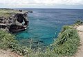 Cliffs at Manzamo
 -
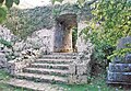
 Gusuku wall
 -
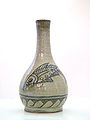 Okinawa Island is the home of Tsuboya-yaki, pottery in the Ryūkyūan tradition.
 -
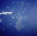 Okinawa Island from Space Shuttle Mission STS-43 (Earth Sciences and Image Analysis, NASA-Johnson Space Center)
 -
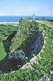
 Gusuku Ruins
 -
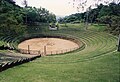 Bullfighting arena. Okinawa is the home of a form of bullfighting sometimes compared to sumo
 -
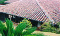 Traditional Okinawan house
 -
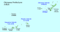 Map of Okinawa Prefecture showing location of Okinawa Island
 -
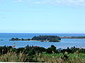 Village of Onna
 -
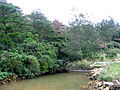 Pond
Pond -
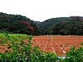 Farmland on Okinawa Island
 -
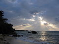 A beach on Okinawa


References
- ^ Beare, Sally (2005). 50 Secrets of the World's Longest Living People. Da Capo Press. p. 304.
- ^ Arashiro Toshiaki High School History of Ryukyu, Okinawa, Toyo Kikaku, 2001, p12,ISBN 4-938984-17-2 p20
- ^ Ito, Masami, "Between a rock and a hard place", Japan Times, May 12, 2009, p. 3.
- ^ http://www.pref.okinawa.jp/toukeika/estimates/estidata.html
- ^ Central Okinawan language at Ethnologue (16th ed., 2009)

- ^ "Gusuku Sites and Related Properties of the Kingdom of Ryukyu." UNESCO: World Heritage Convention.
- ^ Orion Beer Festival and the Cherry Tree Blossom Festival
- ^ Sakura Matsuri
- ^ Century Beach, Pineapple Park and Orion Beer Factory
- ^ a b http://www.japantimes.co.jp/text/fl20120513x1.html
- ^ a b Jaffe, Greg; Heil, Emily; Harlan, Chico (April 26, 2012), "U.S. comes to agreement with Japan to move 9,000 Marines off Okinawa", The Washington Post, washingtonpost.com, retrieved April 28, 2012
- ^ a b http://www.bbc.co.uk/news/world-asia-17865198
- ^ http://www.japantimes.co.jp/text/nn20120516f2.html
- ^ http://www.japantimes.co.jp/text/nn20120428a2.html
External links
 Okinawa Island travel guide from Wikivoyage