Grid reference SU0731
near to Burcombe, Wiltshire, England
Coverage
We have
32 images
in grid square SU0731
Contribute
Explore gridsquare SU0731
Surrounding area
Maps
 Map © Crown Copyright")
TIP: Click the map for more Large scale mapping
Tip: Click the map to open the coverage map
Sample images
Breakdown list
images taken from SU0731 [1]
A sample of 12 photos from 32
for SU0731
- View this square in the Browser >>>
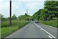
|
A30 heading west |

|
St John the Baptist, Burcombe: churchyard (1)
by Basher Eyre
|
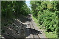
|
Railway cutting at North Burcombe
by David Martin
This is the line from Salisbury to Exeter, looking West.
|
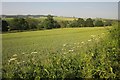
|
Wheat by the A30
by Derek Harper
A long field, rendered sinuous on its other side by meadows along the meandering River Nadder.
|

|
Old Milestone by the A30, North Burcombe, by Church Cottages
by M Faherty
Carved stone post by the A30, in parish of BURCOMBE WITHOUT (SALISBURY District), North Burcombe; opposite bus stop, on South side of road. Hindon stone, erected by the Fisherton, Wilton, Heytesbury, Willoughby Hedge & Redhone turnpike... (more)
|
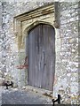
|
Doorway, St John the Baptist Church, Burcombe
Unfortunately the church was locked.
|

|
Farmland at North Burcombe
by David Martin
The distant downs are on the opposite side of the Nadder Valley.
|

|
St John the Baptist, Burcombe: churchyard (2)
by Basher Eyre
|

|
Bench Mark, St John the Baptist Church
The bench mark is to be found on the wall of the porch. Although the stone work is covered with lichen it is in good condition. For a wider view of the church SU0731 : The Church of St John the Baptist, Burcombe and for further information on the bench mark... (more)
|
|
Horse in a paddock, Burcombe
by David Howard
|

|
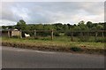
Priory Farm, North Burcombe
Several of the farm buildings at Priory Farm stand beside the A30.
|

|
Milestone, Burcombe Without
Late 18th century limestone pillar with pitched top. The Salisbury to East Knoyle road was turnpiked 1760-62.
|
Explore more images in this square: | View Filtering options | View all 32 images page by page >>> |
|