Grid reference SE3556
near to Knaresborough, North Yorkshire, England
Coverage
We have
474 images
in grid square SE3556
Contribute
Explore gridsquare SE3556
Surrounding area
Maps
 Map © Crown Copyright")
TIP: Click the map for more Large scale mapping
Tip: Click the map to open the coverage map
A sample of 12 photos from 474
for SE3556
- View this square in the Browser >>>

|
A pair of churches, Gracious Street, Knaresborough
by Jeff Gogarty
The Holy Trinity Church is set back and is entered through the archway. The church that can be seen is the United Reformed Church.
|
|
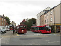
Knaresborough Bus Station
Knaresborough's bus station is quite small, comprising three bus stops just off the town's High Street which passes to the left in this image. High Street forms part of the route of the trunk A59 as it passes through the town.... (more)
|

|
Entrance to Knaresborough Cemetery
by HelenK
Knaresborough Cemetery lies adjacent to the A59, just further out from King James's School. Cemetery Lodge on the left would once have housed the caretaker, but has now been sold off as a private house.
Find a Grave page:... (more)
|

|
Caravan Park - viewed from Crag Lane |

|
Fysche Hall, Knaresborough
by Derek Harper
Built for Francis Isles (d1776) Link
|

|
Low Bridge, Knaresborough
This has been one of the main routes into the town over the River Nidd for centuries. There was a bridge here in Medieval times, known as 'Staynbrigg', whilst in 1642 it was known as 'March Bridge' and was said to be... (more)
|

|
The 'Half Moon', Knaresborough
On the north side of the river, just near Low Bridge
|

|
Princess Drive - York Road |

|
Plaque to Our Lady of the Crag
by Martin Dawes
On a wall on Abbey Road
|

|
Co-op supermarket, Chain Lane
At the moment this is the only supermarket in Knaresborough.
March 2018 update: The supermarket has now been demolished and the site is being redeveloped, whilst at the entrance is a sign for Lidl supermarket, which gives the impression... (more)
|

|
The Marquis of Granby
by Ian S
One of three Sam Smith's pubs in Knaresborough
|

|
Cottage, Briggate
by N Chadwick
|
Explore more images in this square: | View Filtering options | View all 474 images page by page >>> |
|