

Lommedalen: Difference between revisions
Piratesswoop (talk | contribs) she's not THE princess of norway |
|||
| (46 intermediate revisions by 34 users not shown) | |||
| Line 1: | Line 1: | ||
{{Infobox |
{{Infobox settlement |
||
<!--See Template:Infobox Settlement for additional fields that may be available--> |
|||
<!--See the Table at Infobox Settlement for all fields and descriptions of usage--> |
|||
<!-- Basic info ----------------> |
|||
|name = Lommedalen <!-- at least one of the first two fields must be filled in --> |
|name = Lommedalen <!-- at least one of the first two fields must be filled in --> |
||
|official_name = |
|official_name = |
||
|other_name = |
|other_name = |
||
|native_name = |
|native_name = <!-- if different from the English name --> |
||
|nickname = |
|nickname = |
||
|settlement_type = Village<!-- e.g. Town, Village, City, etc.--> |
|settlement_type = Village<!-- e.g. Town, Village, City, etc.--> |
||
|total_type = <!-- to set a non-standard label for total area and population rows --> |
|total_type = <!-- to set a non-standard label for total area and population rows --> |
||
|motto = |
|motto = |
||
<!-- images and maps -----------> |
<!-- images and maps -----------> |
||
|image_skyline = Lommedalen.jpg |
|image_skyline = Lommedalen.jpg |
||
| Line 16: | Line 13: | ||
|image_caption = Late winter vista of Lommedalen |
|image_caption = Late winter vista of Lommedalen |
||
|image_flag = |
|image_flag = |
||
|flag_size = |
|flag_size = |
||
|image_seal = |
|image_seal = |
||
|seal_size = |
|seal_size = |
||
|image_shield = |
|image_shield = |
||
|shield_size = |
|shield_size = |
||
|image_blank_emblem = |
|||
|blank_emblem_type = |
|||
|blank_emblem_size = |
|||
|image_map = |
|image_map = |
||
|mapsize = |
|mapsize = |
||
|map_caption = |
|map_caption = |
||
| ⚫ | |||
| ⚫ | |||
|map_caption1 = |
|||
|image_dot_map = |
|||
|dot_mapsize = |
|||
|dot_map_caption = |
|||
|dot_x = |dot_y = |
|||
|pushpin_map = Akershus<!-- the name of a location map as per http://en.wikipedia.org/wiki/Template:Location_map --> |
|pushpin_map = Akershus<!-- the name of a location map as per http://en.wikipedia.org/wiki/Template:Location_map --> |
||
|pushpin_label_position = top<!-- the position of the pushpin label: left, right, top, bottom, none --> |
|pushpin_label_position = top<!-- the position of the pushpin label: left, right, top, bottom, none --> |
||
|pushpin_map_caption = Location in Akershus |
|pushpin_map_caption = Location in Akershus |
||
|pushpin_mapsize = |
|pushpin_mapsize = |
||
<!-- Location ------------------> |
<!-- Location ------------------> |
||
|subdivision_type = Country |
|subdivision_type = Country |
||
| Line 46: | Line 33: | ||
|subdivision_name2 = [[Bærum]] |
|subdivision_name2 = [[Bærum]] |
||
<!-- Politics -----------------> |
<!-- Politics -----------------> |
||
|government_footnotes = |
|government_footnotes = |
||
|government_type = |
|government_type = |
||
|leader_title = |
|leader_title = |
||
|leader_name = |
|leader_name = <!--add (no-break space) to leader names to disable automatic links--> |
||
|leader_title1 = |
|leader_title1 = |
||
|leader_name1 = |
|leader_name1 = |
||
|established_title = |
|established_title = <!-- Settled --> |
||
|established_date = |
|established_date = |
||
<!-- Area ---------------------> |
<!-- Area ---------------------> |
||
| ⚫ | |||
|area_magnitude = |
|||
| ⚫ | |||
| ⚫ | |||
|area_total_km2 = <!-- ALL fields with measurements are subject to automatic unit conversion--> |
|||
|area_footnotes = |
|||
| |
|area_land_km2 = <!--See table @ Template:Infobox Settlement for details on unit conversion--> |
||
| ⚫ | |||
|area_land_km2 = <!--See table @ Template:Infobox Settlement for details on unit conversion--> |
|||
| |
|area_water_percent = |
||
|area_total_sq_mi = |
|||
|area_land_sq_mi = |
|||
|area_water_sq_mi = |
|||
|area_water_percent = |
|||
<!-- Elevation --------------------------> |
<!-- Elevation --------------------------> |
||
|elevation_footnotes = |
|elevation_footnotes = <!--for references: use <ref> tags--> |
||
|elevation_m = |
|elevation_m = |
||
| |
|elevation_max_m = |
||
| |
|elevation_min_m = |
||
|elevation_max_ft = |
|||
|elevation_min_m = |
|||
|elevation_min_ft = |
|||
<!-- Population -----------------------> |
<!-- Population -----------------------> |
||
|population_as_of |
|population_as_of = |
||
|population_footnotes |
|population_footnotes = |
||
|population_note |
|population_note = |
||
|population_total |
|population_total = 3000 |
||
<!-- General information ---------------> |
<!-- General information ---------------> |
||
|timezone = [[Central European Time|CET]] |
|timezone = [[Central European Time|CET]] |
||
| Line 83: | Line 63: | ||
|timezone_DST = [[Central European Summer Time|CEST]] |
|timezone_DST = [[Central European Summer Time|CEST]] |
||
|utc_offset_DST = +2 |
|utc_offset_DST = +2 |
||
|coor_pinpoint =<!-- can be used to specify exactly where/what the coordinates refer to --> |
|coor_pinpoint = <!-- can be used to specify exactly where/what the coordinates refer to --> |
||
| |
|coordinates = {{coord|59|57|N|10|28|E|region:NO-0219_type:city|display=inline,title}} |
||
|coordinates_display = inline,title |
|||
|latd=59 |latm=57 |lats= |latNS=N |
|||
|longd=10 |longm=28 |longs= |longEW=E |
|||
<!-- Area/postal codes & others --------> |
|||
|postal_code_type = [[List of postal codes in Norway|Postal code]]<!-- enter ZIP code, Postcode, Post code, Postal code... --> |
|postal_code_type = [[List of postal codes in Norway|Postal code]]<!-- enter ZIP code, Postcode, Post code, Postal code... --> |
||
|postal_code = 1350 |
|postal_code = 1350 |
||
|area_code = |
|area_code = |
||
|website = |
|website = |
||
|footnotes = |
|footnotes = |
||
}} |
}} |
||
| ⚫ | '''Lommedalen''' is a |
||
| ⚫ | |||
| ⚫ | |||
| ⚫ | Lommedalen includes wooded areas, some agricultural land, and residential zones. |
||
|title =Lommedalen|publisher = Store norske leksikon|author=Svein Askheim|accessdate= September 15, 2016}}</ref> |
|||
| ⚫ | Lommedalen includes wooded areas, some agricultural land, and residential zones. It includes parts of the forest area [[Krokskogen]]. The river Lomma runs through the valley. A [[forest road]] from Lommedalen goes to [[Hole, Norway|Hole]] in [[Buskerud]]. The pilgrim road to [[Nidaros Cathedral]] in [[Trondheim]] passed through Lommedalen in medieval times and was resurrected in celebration of the 1000th anniversary of Trondheim in 1997. |
||
Lommedalen is a popular area for [[skiing]] in winter time and horse back riding in summer time. It is also home to two golf courses, Lommedalen Golf Club and Bærum Golf Club. |
|||
Lommedalen is a popular area for [[skiing]] and [[Slalom skiing|slalom]] in winter time and horseback riding in summer time. Lake Burudvann is a popular hiking destinations and seaside resort located in the area. The area is also home to two golf courses, Lommedalen Golf Club and Bærum Golf Club. Lommedalsbanen is a narrow gauge railway museum located at the top of the valley. Lommedalen church (''Lommedalen kirke'') dates from 1995. The building material is stone and brick. The church is of rectangular plan and 700 number of seats.<ref>{{cite web|url = https://snl.no/Burudvann|title = Burudvann|publisher = Den Norske Kirke |
|||
[[Princess Märtha Louise of Norway]], now lives in Lommedalen with her family. They moved there in [[2003]]. |
|||
|author = Svein Askheim|accessdate = September 15, 2016}}</ref><ref>{{cite web|url = http://www.kirkesok.no/eng/kirker/Lommedalen-kirke|title = Lommedalen kirke|publisher = Den Norske Kirke|accessdate = September 15, 2016}}</ref><ref>{{cite web|url=https://snl.no/Lommedalsbanen|title =Lommedalsbanen|publisher = Store norske leksikon|author=Svein Askheim|accessdate= September 15, 2016}}</ref> |
|||
==People associated with Lommedalen== |
|||
| ⚫ | |||
*[[Ari Behn]] (1972–2019), author and ex-husband of [[Princess Märtha Louise of Norway|Princess Märtha Louise]], and their children [[Maud Angelica Behn|Maud Angelica]] and [[Leah Isadora Behn|Leah Isadora]] |
|||
*[[Narve Bonna]] (1901–1976) ski jumper |
|||
| ⚫ | |||
*[[Leif Kristian Haugen]] (b. 1987) World Cup alpine ski racer |
|||
*[[Aleksander Aamodt Kilde]] (b. 1992) World Cup alpine ski racer |
|||
*[[Thomas Rogne]] (b. 1990) football (soccer) player |
|||
*[[Rune Velta]] (b. 1989) ski jumper. |
|||
==Gallery== |
|||
<gallery> |
|||
File:Framed view (6132003631).jpg|View of Lommedalen |
|||
| ⚫ | |||
File:Koret øver i Lommedalen kirke.jpg|Lommedalen Church interior |
|||
File:Lommedalsbanen 140720086586.jpg|Lommedalsbanen |
|||
</gallery> |
|||
==References== |
|||
{{reflist}} |
|||
{{Sections of Bærum}} |
{{Sections of Bærum}} |
||
| ⚫ | |||
{{authority control}} |
|||
[[Category:Bærum]] |
[[Category:Bærum]] |
||
[[Category:Villages in Akershus]] |
|||
[[Category:Forests and woodlands of Norway]] |
|||
[[no:Lommedalen]] |
|||
| ⚫ | |||
[[pl:Lommedalen]] |
|||
Latest revision as of 06:55, 14 September 2023
Lommedalen | |
|---|---|
Village | |
 Late winter vista of Lommedalen | |
 Lommedalen Location in Akershus | |
| Coordinates: 59°57′N 10°28′E / 59.950°N 10.467°E | |
| Country | Norway |
| County | Akershus |
| Municipality | Bærum |
| Population | |
| • Total | 3,000 |
| Time zone | UTC+1 (CET) |
| • Summer (DST) | UTC+2 (CEST) |
| Postal code | 1350 |
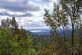
Lommedalen is a rural community in a small valley in Bærum municipality in the county of Akershus, Norway. The population is about 3,000 people. Lommedalen valley opens up at Bærums Verk and runs about 5 kilometers to the north.[1]
Lommedalen includes wooded areas, some agricultural land, and residential zones. It includes parts of the forest area Krokskogen. The river Lomma runs through the valley. A forest road from Lommedalen goes to Hole in Buskerud. The pilgrim road to Nidaros Cathedral in Trondheim passed through Lommedalen in medieval times and was resurrected in celebration of the 1000th anniversary of Trondheim in 1997.
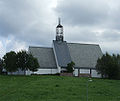
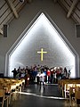
Lommedalen is a popular area for skiing and slalom in winter time and horseback riding in summer time. Lake Burudvann is a popular hiking destinations and seaside resort located in the area. The area is also home to two golf courses, Lommedalen Golf Club and Bærum Golf Club. Lommedalsbanen is a narrow gauge railway museum located at the top of the valley. Lommedalen church (Lommedalen kirke) dates from 1995. The building material is stone and brick. The church is of rectangular plan and 700 number of seats.[2][3][4]
People associated with Lommedalen
[edit]- Ari Behn (1972–2019), author and ex-husband of Princess Märtha Louise, and their children Maud Angelica and Leah Isadora
- Narve Bonna (1901–1976) ski jumper
- Magnus Carlsen (b. 1990) chess player
- Leif Kristian Haugen (b. 1987) World Cup alpine ski racer
- Aleksander Aamodt Kilde (b. 1992) World Cup alpine ski racer
- Thomas Rogne (b. 1990) football (soccer) player
- Rune Velta (b. 1989) ski jumper.
Gallery
[edit]-
 View of Lommedalen
 -
 Lommedalen Church
 -
 Lommedalen Church interior
 -
 Lommedalsbanen


References
[edit]- ^ Svein Askheim. "Lommedalen". Store norske leksikon. Retrieved September 15, 2016.
- ^ Svein Askheim. "Burudvann". Den Norske Kirke. Retrieved September 15, 2016.
- ^ "Lommedalen kirke". Den Norske Kirke. Retrieved September 15, 2016.
- ^ Svein Askheim. "Lommedalsbanen". Store norske leksikon. Retrieved September 15, 2016.
This Akershus location article is a stub. You can help Wikipedia by expanding it. |